Trying to find sponsors for your sport, dream or challenge? Not easy! After all, who wants to pay for your dream, which happens to be on some high, remote, extremely cold mountain?
Well, to be honest? I think lots of organizations do, but it’s not easy. And before I raise any expectation, I haven’t found one yet either. But, I did look into the subject and have tried one or two things. So I do think I
have some experience.
Before getting to the point, let’s have a short look at how most mountaineers get sponsors.
Two traditional options
Most mountaineers focus on good, and of course bad, things they l
earn from mountaineering. They translate their experiences towards everyday situations and use this to bring some important message to their sponsors. Most of you know this as a motivational speech. Add some impressive climbing photo’s and all elements of a great presentation are there.
To sell this well, you need to be a good speaker. And it really helps if something really bad happens during the climb. Lose a limb or two or barely survive. The more goes wrong, the better the story, the more people love to listen to it!
Your second option is to commit to a charity. For me, the most successful example of this is Alan Arnette. He committed himself to raising money for research on Alzheimer’s disease. His link to the disease is strong since his mom died of it. So Committing to a charity requires a strong belief in the goal the charity organization is aiming at. You can connect your name to the organization, and will (hopefully) be able to raise money and find a way to get enough funds for your personal goals.
Don’t be sponsored, influence!
Social media offers some great features, and I probably don’t have to tell you social media is huge. Anyone can tell anything about whatever you want. And if you do it the right way, people start listening and your opinion gets valued more and more. After all, you, as a mountaineer know best what the right stuff to use for mountaineering.
This is where Endrse.com comes to play. The people of Endrse offer an excellent platform to bring together skilled people and organizations that need your network and opinion. They are constantly looking for organizations that benefit from good reviews on gear, clothes, support, etc. All you need to do is tell what you think about their product to as many people as possible. And the easiest way to do that is… social media!
So make sure as many people as possible like, follow or read everything you publish on social media. Register at Endrse.com and chances are they will help you to get in touch with the right organizations!
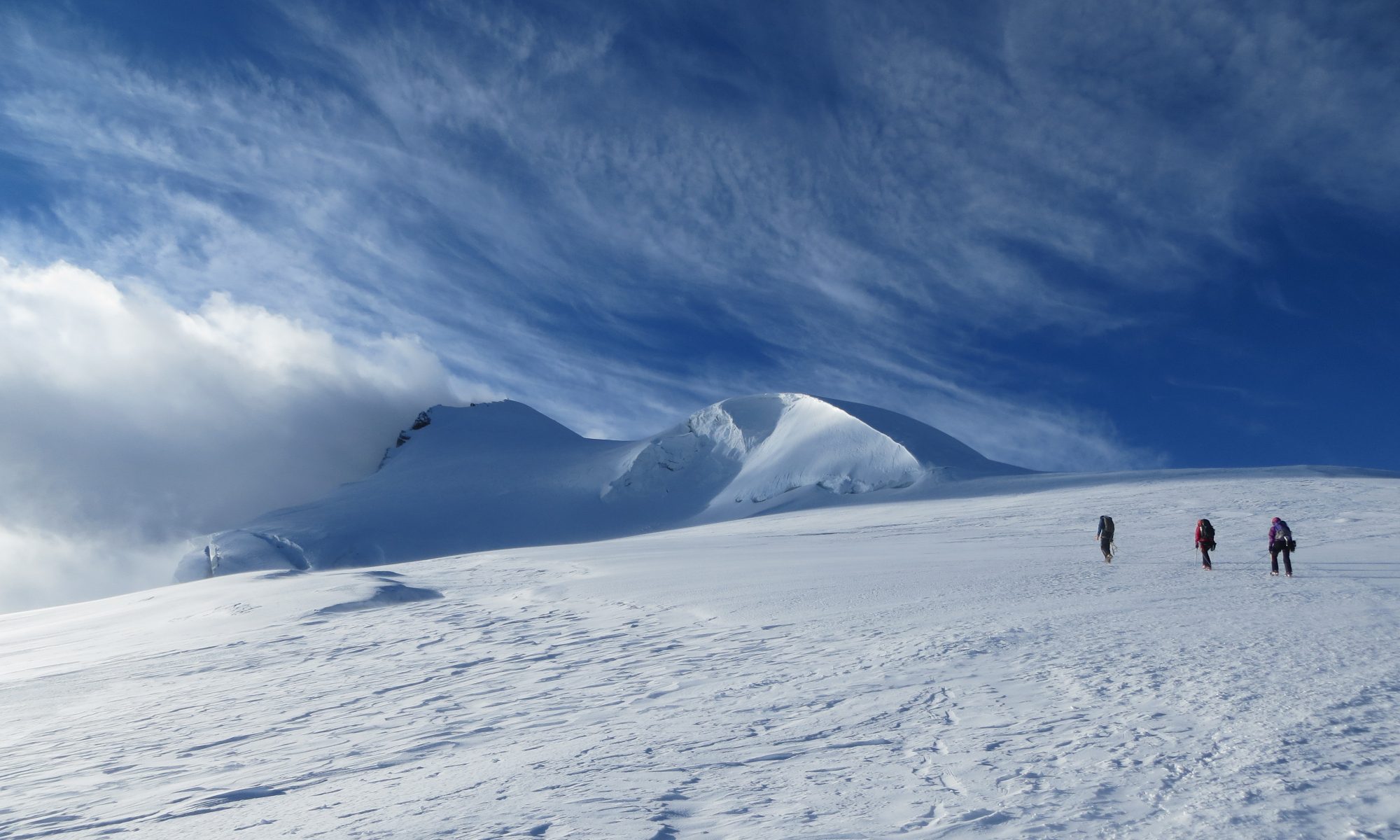
Back to training! Currently I am busy working out a plan for 2018. Chances are I’ll return to Denali. But this time with a private team. No guides, no help, just the team. More on that later!
But while this is still work in progress, my training preparations have already begun. To get back in shape I roughly follow the same schedule as last year. One big change is the hardware around my wrist; a Garmin Fenix 5x (See Gamins page for full info on the watch). I wear this excellent watch daily, and I just love it. I love it so much, I want to tell you about it!
Since I do a pretty wide variety of sports, I will share my experienceswhile mountaineering, trekking and training (cycling and running). No matter how you use the Garmin Fenix 5x, the watch is comfortable. No further discussion on this!
Mountaineering
For mountaineering, I basically need two things; current time and change in altitude since I started climbing.
Knowing the current altitude can help you navigate. But, at the same time, your barometer can also tell you something about the current weather. Upcoming bad weather (thunder for example) might be coming if the current altitude on your watch changes dramatically in a short period of time.
The Garmin Fenix 5x has a barometric pressure sensor. This, in combination with GPS, should be enough to get accurate altitude information. However, having two altitude sensors doesn’t mean the Garmin Fenix 5x always displays the correct current altitude. At the moment of writing (this article took rather long to finish 🙂 ), I’m sitting in the Wangenitzseehütte in Austria. The sign on the hut tells me the current altitude is 2505m, but my Garmin Fenix 5x displays only 2461m. As you probably know, GPS is getting less accurate the higher you get, so despite having GPS, it’s still necessary to keep calibrating your devices and known altitudes. No problem, just remember this.
The other important thing works flawlessly; time. But that is very much expected from a watch. One thing that is very convenient is that it automatically changing time zones while traveling. This is done by syncing time to your phone.
While mountaineering, I usually use GPS in UltraTrac mode. The mode limits GPS accuracy, but improves battery lifetime. So far, this has mostly resulted is some strange routes and distances on Strava. But I am very happy with the battery life of my Garmin Fenix 5x. It easily lasts a long day of climbing.
Training
This is where the Garmin Fenix 5x truly shows its abilities. Like most Garmin devices, the Fenix is able to sync your training data with Garmin Connect. Here, you see tons of data about your training sessions and how effective they are. One nice feature of the Fenix is that it is able to display how effective your current training is, if you training load is manageable, and what your current VO2 max is.
Garmin has tons of training schedules programmed into Garmin Connect. While using such a program, the Garmin Fenix 5x nicely displays useful information at the right time. For running; your current heart rate, training zone, current pace and time left. And after about 5 minutes it displays how you are performing given your current VO2 max.
All Fenix watches have a built in heart rate monitor. Don’t be fooled by this though! For good accuracy during your workout, a chest strap is still necessary. I have found the internal heart rate monitor is inaccurate and too slow the be able to train effectively with.
Is it completely useless? No, it’s not. The Fenix will monitor you heart rate 24/7, giving you some nice insight about, for example, you heart rate at rest and your daily activities. And for low intensity activities, like walking, the internal heart rate monitor is sufficient.
Trekking
Yes, navigation time! This is the reason why I chose for the Fenix 5x instead of the Fenix 5(s). The Garmin Fenix 5x is the only watch in the series equipped with maps, and thus navigation option. I am really surprised by the amount of detail of the maps and ease of the maps. During my last trek in Iceland, I noticed the Laugavegur is on the maps by default; one very nice feature that helped me a couple of times to get back on track. GPS on the device is accurate.
On bad thing though is that it’s not easy to copy a GPX-file from the PC or Smartphone to the devices. To copy a GPX-file, you have to attach the Fenix to you PC and then copy it. However, the Fenix has Bluetooth so why not use that? As far as I know there currently is no way to add a route using you smartphone.
It has a lot of nifty features besides just navigating, but I haven’t used, of even found, them yet.
Conclusion
It’s hard to describe all the features of this extensive watch without writing a complete book. There are tons of features, I am still discovering more and more, and I am not even using all of them (Strava Live Segments, for example).
Speaking for myself, I am very impressed with the watch. Sure, it has some flaws (connectivity with your phone, for example), but they are very acceptable.
Is it really worth the money? That is an answer you have to answer yourself. I wouldn’t want any other watch (at the moment 🙂 ).
For a complete review, including all features, review of the Garmin Fenix 5x, have a look at the excellent site of DC Rainmaker.
I would like the thank Juwelier De eenhoorn for helping me getting the Garmin Fenix 5x just before my trip to Denali.
After my summit attempt on Denali, it was not yet time to go home. Last year on Elbrus I found out that climbing is pretty intense for the mind too. I booked my trip to Alaska using Iceland Air, and Iceland Air offers a free stopover at Iceland. This would be an excellent opportunity to do the Laugavegur trek in Iceland, and recover a little from Denali… At least, that was my plan.
The trekking season on Iceland starts end of June – beginning of July. The conditions of the roads leading towards the treks are too bad for the buses to get there earlier in the season. So one of the first things I did on my return in Anchorage was to check the current state of the Iceland-roads. Facebook told me the good news; roads would open on the day before I wanted to start the Laugavegur trek. Now that’s some excellent planning!
Day 1
My bus departed from Reykjavik to Landmannalaugar at 8:00h. In three
Start of the Laugavegur
hours we got to Landmannalaugar where the Laugavegur trek really began. During the bus ride, weather was good and some interesting facts were told about the Icelandic landscape. I enjoyed the bus ride, with great views. It’s just incredible to be inIceland; the country just feels so young and still under heavy construction; one thing that is made very clear by the number of active volcanoes.
The actual trekking started in the beginning of the afternoon. When I was just about to take off, someone warned me about half of the trail would still be in snow. Conditions weren’t ideal, but since I had just spent 3 weeks on a glacier, I wasn’t too afraid of that. I started the trail and it didn’t take long before I got in the first snowfields. People around me were struggling, but I just kept on going.
The first day of the Laugavegur is the day you get to the highest hut; the Hrafntinnusker hut at about 1000m altitude. The trail was almost constantly covered with snow but, as I said before, that was no problem for me. Unfortunately, I could not get any views either. The views were completely blocked by fog, making the day pretty boring after a while.
Out of the wind and out of the snow
It took me about 4 hours to get to the Hrafntinnusker hut. The land was completely covered with snow and it was windy. I could find some shelter from the wind behind the hut and had a good spot for the tent. But I hoped very much to get some better weather tomorrow.
Day 2
Day 2 of the Laugavegur trek started as day 1 ended: foggy, windy and pretty cold. But, I was told I was going to descend today and therefor get out of the snow and the fog. And indeed I did! After about 2 hours of hiking, I could actually look around and see something! This was the first time I understood why the Laugavegur is such a beautiful trek. I could see the lower green lands, the upper white hills and the brown landscape I was currently in. I sat down on a rock for a while, just to enjoy the area and wash away last night’s bad weather.
But, sitting around and thinking didn’t get me any further. It was time to
Finally, blue skies!
continue the descent, cross the first river (bare feet and cold water!), and get to the next hut; Álftavatn. I arrived at this hut around 15:00h. Setting up my tent, cooking dinner and eating would take me about an hour. If I were to stop now, I would have a very long evening. Not good, so I decided to go to the next hut. Since the Hvanngil hut is very close to the Álftavatn hut, it only took me about 30 minutes to get there. Same thoughts, and same conclusion; it’s still too early to camp.
Lets go on!
To get to the next hut at Emstrur, there were 2 things I had to do; cross a pretty deep and wide river and the black dessert. Crossing the river didn’t turn out to be much of a problem. I knew a good way to do it, found a
The black desert being … black!
pretty good spot, so nothing could stop me. But still.. the water was cold and the river was over knee deep. Cold water and warm muscles are not a good combination, I found out. The cold really hurt my calves, and the annoying pain would slowly climb up my legs. Some 30 minutes after crossing the river, I could still feel the cold!
After the river I hiked straight into the black desert. The black desert is, as you might expect, just a plain surface with black sand. And as most deserts, it’s pretty endless. I started hiking on a car trail, but later the trail took a left turn. I wasn’t paying much attention at that moment, so I missed that turn. By accident I had a look at my watch 15 minutes later, and noticed I was no longer on the trail (I have a Garmin Fenix 5x with navigation). Thanks watch! After a couple of hours the black desert finally ended. My feet where sore, my legs felt empty, but I was in Emstrur. I did a 31Km hike. I knew I was tired enough to have a good night’s sleep!
Day 3
Day 3 started with a good breakfast and of course packing everything. After about 10 minutes of hiking, I passed a sign telling me what to do in case of a volcano eruption under the glacier nearby. It said there will probably will be a flood and that all local huts will fire a loud bang. The next thing is to get to the highest point nearby. This is just another moment I realized the island itself is still very much alive. But luckily (or not?) the volcano kept sleeping.
This day again surprised me with two totally different landscapes during the day.
Rivers needed to be crossed
The beginning of the trail was rocky and hilly, but the land got progressively more flat during the day. I had to cross one more cold and wide river. After that, I hiked for about half an hour in the woods. These woods marked the end of the Laugavegur trail when I arrived at the hut in Þórsmörk.
Yesterday I did two stages and now I am at the end of the Laugavegur trail: there was plenty of time to hike a bit further. I had been thinking about what to do now for I while. I decided to extend my hike with the Fimmvörðuháls hike (yes, try to pronounce that!). The Fimmvörðuháls is a 30km trail between Þórsmörk and Skógar. There is a hut after 15km, which was going to be my destination for today.
Stage two of day 3
First I had to cross a wide river bedding to the Básar hut, where the trail really begins. After the Básar hut the trail started to climb across a stunning ridge. At one side there was a beautiful sight at the Krossá river, and on the other side there was a deep gully with another small river at the bottom. After this ridge I got to a flatter portion where it started to get windy (I was about 600m above
Beautiful views
sea level) and raining.
The weather was getting worse, the wind were getting stronger and the rain got heavier. Time to switch to my rain jacket and pants, get on gloves and be prepared for some bad weather. The trail was going to climb to 1043m, where the Fimmvörðuháls pass is located. Going up usually means the weather will not get better; that’s what I learned on the first day of the Laugavegur.
Today was no different. Winds were really bad, rain was pouring down and the fog prevented me from seeing anything but white. I was constantly walking on snow, which made it hard to keep a good pace. The day was getting long and my body was getting tired from walking over 30km two days in a row. At around 20:00h I finally arrived at the Fimmvörðuskáli Hut. It was still windy and rainy. I thought about setting up my tent, but didn’t really see a good spot and thought my tent would probably be soaked before it was setup properly, so I decided to spend the night in the hut. Luckily there was plenty of room and I had a good sleep.
Day 4
Day 4 started as day 3 ended; rainy, windy and foggy. It was only 15km more to Skógar, and the trail was going downhill all day, so I had an easy start. My jacket, pants and beanie were still wet, so I gave them a little more time to dry (or get less wet). Luckily I did have another pair of dry gloves!
Around 11:00 it was finally time to get going. The weather was still bad, but I had
White, wet, soaked… but the weather was getting better
to go down today and catch my bus back to Reykjavik. While descending, the weather slowly got better. The fog disappeared (or better said, I got below the clouds) and constant rain changed into showers. But, the best thing was I got to see the surroundings! Something I missed yesterday, and they were supposed to be beautiful.
Today the surroundings wereall about waterfalls; during the hike today I saw plenty. The next one even more impressive than the previous. Of course the most impressive one is the waterfall in Skógar where
The end at Skógar
the water falls over 60m. But everything comes with a price; while getting closer to Skógar the number of tourists increased, blowing away the silence and rest.
Another bad thing was that Skógar was the end of my hike on Iceland and my 4 weeks of climbing and trekking in Alaska and Iceland. All that was left was to get the bus back to Reykjavik and catch the plane back to Amsterdam.
Conclusion
The Laugavegur and the Fimmvörðuháls in Iceland are both stunning treks. Both are famous which may make them crowded during high season. If you like to be alone and enjoy the silence like me, be sure to do them pre- or post season. But there is a downside to this; the weather. During my stay in Iceland, the weather was great on the lowlands, but I had white-outs every time I got around 1000m in altitude.
Will I come back to Iceland? If I have the chance, I will for sure. Iceland is a great country. People are very friendly, but the island is expensive. One way to deal with this is to camp as much as possible, and bring your own food. Be aware
With good weather, Iceland is just great
though, backcountry camping is not permitted!
Looking back, I did not get the rest and time to think that I had planned. I enjoyed Iceland and the treks a lot, but, I also found a new challenge; long and intense days. After doing almost 70km in two days, with pretty hard conditions, my body was tired and needed some recovery, but my mind was still ready to go on another climb or trek!